

Do not run away, only the title will be in French?and I will even translate it for you: "A hike to Roche-Plate." And yes, Roche-Plate, not Flat-Stone as this is a place on Reunion and today we will slip on our best hiking boots for a nice walk in the heart of the island.
This previous article describes Reunion island. It is a small place but has a surprisingly high number of trails, paths, tracks and all manners of ways to ramble through its mountains and forests. As a matter of fact, those trails are the only way to get to many parts of the island as the steep relief and large number of gullies prohibits building roads or even cart-tracks. The history of Reunion is rather young and folks who first settled on its shores soon began exploring the inner parts for a variety of reasons: to find usable land to settle, secluded places to hide or search for escaped slaves. This soon led to an extensive network of trails leading all around and many are still in active use as some people still live in quite remote areas. For example, some 700 residents live in the ‘Cirque de Mafate' and can be reached only on foot or by helicopter. Nowadays many trails are used solely for tourist activity, both local tourists and visitors from abroad. The one we will enjoy today is mostly used by local tourists but if you stick close to me nothing too bad should happen to you...
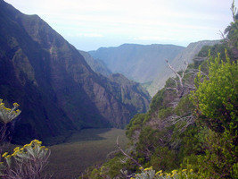 The trail starts at a place called ‘Le Nez de Boeuf' which translates as ‘the ox's nose' and sounds as strange in French as in English. This place is found on the road going to our still-active (very active at times!) volcano, at some 2100 m high (roughly 6300 feet) so we may need a sweater (a hike usually starts early.) A friendly neighbour or any other nice person will drop us off as there are no buses and we cannot leave the car there because we are not coming back the same way. So with good shoes on, comfortable hiking clothes, water, snacks, and camera plus your first-aid kit, you're ready. This is only a 10km walk, which should take about four hours to complete. Before going down we can enjoy a very nice scenery from the top of the trail as we cross a large gully that transforms into the ‘Rivière des Remparts', leading to Saint-Joseph, the southernmost town of Reunion.
 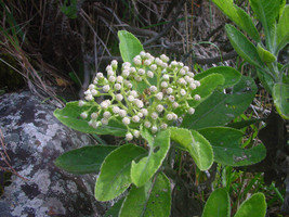 At this altitude plants are scarce but we can enjoy a few interesting endemic species such as Acacia heterophylla locally known as ‘tamarin des hauts' and which can grow to a pretty impressive size. Another endemic tree--though much smaller--is the Sophora denudata with small yellow flowers. A few species of the Ericaceae family (the heathers) show us that we are at some altitude; they include Philippia montana, Stoebe passerinoides and Eriothrix sp. The first hour of walk is the most strenuous as we go down a very steep and narrow path with many slippery rocks which require sharp attention. As we slowly proceed down, the plant species change. The heather-related ones disappear while others show up: Aphloia theiformis with its decorative desquamating bark, and the usual invasive ones also become more present, like Fuschia x exoniensis, Solanum mauritianum and the thorny Lantana camara. Once we reach the bottom of the ravine, it gets much easier and we can fully enjoy the walk and the plants without falling over. Some interesting ‘mapou' (Monimia sp.) grow here as a forest and there are some very large specimens. A few orchids are blooming (this is March, the end of cyclonic season) such as Jumellea erecta, Benthamia latifolia and the colourful Calanthe sylvatica which we have to avoid stepping on at times as it grows right on the path. If the year has been rainy there will be some waterfalls and natural basins every once in a while, a nice refreshing stop. And after some three more hours we will reach Roche-Plate, a former village at 740m of altitude. It used to be lively in old times but most people have left to go on the coast and only a few houses remain, with two lodges where one can sleep in basic wooden houses,
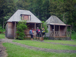
 but the wooden-fire cooked food is delicious and worth the effort to get there! There is usually a track that can be used by four-wheel-drive cars from St-Joseph, but it is regularly swept by cyclones and therefore people have to walk the 13km to get there and another 13km back. Anyway, after a few hours of serious hiking, a good meal ending with some ‘rhum arrangé' there is no difficulty whatsoever to find sleep...
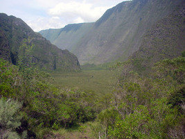
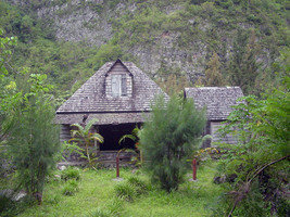
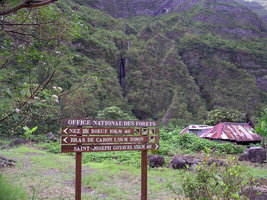 On the following morning it is time to pack again and hit the track. This second part will lead us along the Rivière des Remparts all the way back to civilisation at St-Joseph. It is a much easier walk though not very exciting in the end. We start by going through Roche-Plate which allows us to see the great work the ancients undertook to build stones walls that delineate gardens and places for animals, mostly poultry, pigs and goats. As the walls have long been unused, they have been slowly taken over by a variety of plants coming from the former gardens around like roses, irises, African lilies and so on. Most houses, made of wood, are abandoned and in poor shape. The trail goes for about 2km under high Casuarina trees planted a long time ago. Then we reach a large fork where the Rivière des Remparts meets the Bras de Mahavel.
 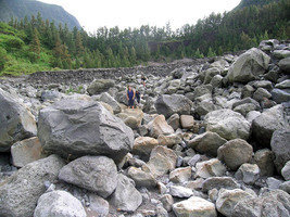 Now we are in the dry river bed about 300m wide and we walk through a mix of sand, stones, rocks, pebbles, shingles and blocks, a geologist's dream but a botanist's nightmare...Mahavel has a special story: in 1965 a large part of cliff collapsed and 15 million cubic meters of rocks suddenly came down. The inhabitants of Roche-Plate and St-Joseph thought an eruption or earthquake was taking place. This fantastic mass made a natural dam behind which water started to fill until it represented a potential danger for St-Joseph; if it suddenly broke the city would be swept by a gigantic wave. After several ineffective trials, the army decided to blow open an aperture so as to release the water slowly and later on managed to take the dam down with much hard work.
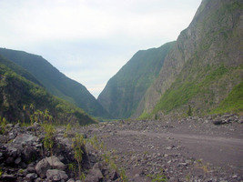
At last we reach St-Joseph where our still-friendly neighbour will pick us up. This is just one of the numerous hikes we can undertake in this wonderful island. If you have enough time, reliable legs and a good heart you can walk across the whole island--some people even run from St-Joseph to St-Denis on the North coast, an event known as ‘la diagonale des fous' as you certainly have to be a little crazy to do such a thing and not take time to enjoy it...
Copyright © www.100flowers.win Botanic Garden All Rights Reserved